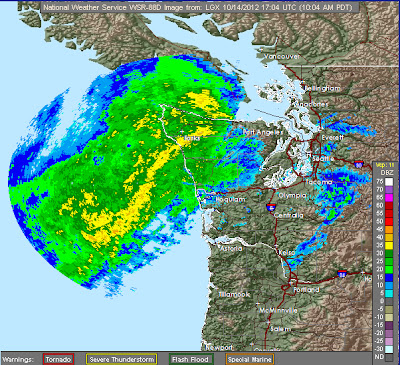
In the old days, before the coastal radar we would only seen a bit of this intense band. Here is the current Camano Island radar image:

And here is the Portland radar.


To show you have valuable a radar is, here is the latest high-resolution visible satellite imagery. Hard to tell what is going on offshore.

We have just passed the one-year anniversary of the installation of this radar, the acquisition of which was greatly aided by sustained efforts of Senator Maria Cantwell and her staff.
You may have noticed how warm and humid the air is. We are now in a subtropical current of warm air from the southwest. Here are the temperatures at the UW...well into the 60s even with lots of clouds.

Anyway, the rain is coming..it will be a wet afternoon here in Seattle.


While there are things I need to do outside - I'm actually enjoying the rain. Where I'm at (Sumner area) it's not raining hard enough to be annoying. The temp is still warm, and the sound of the raindrops is like music!
ReplyDeleteI reserve the right to change my opinion, come February or March.
Any one have ideas on how to get a copy of this post to Maria Cantwell? Cliff has written a beautifully documented verification of the value of our new radar. I think that she and Cliff deserve some thanks for the years of effort that they put into making this happen. After months of comparison, I can say that LGX gives me a better view of what is going on 65 miles inland from the coast in Olympia than ATX does. It's not just a coastal radar.
ReplyDeleteThanks to you both!
One solid inch -- well, liquid -- here at 210' ASL in Bellevue. The new radar is awesome and this weekend proves its value to most of us... it will probably save someone's life at some point because we will never have another sneak-up surprise storm like Columbus Day.
ReplyDeleteDoes the new radar also show wind velocities? If so, is there a way for the public to access these? Where we live, wind is a much greater threat than rain, so it would be good to know what to expect for wind as well as for rain.
ReplyDeleteFirst time viewing your blog. Love the way you captured the benefits of the new Langley Hill radar. I do have a question for you though. This year we've seen more lightning than any year I can remember (25+ in Puget Sound/SJdF area). Is there a correlation between lightning storms and warmer temps such that we will receive more thunderstorms as our regional climate changes?
ReplyDelete